All the elements of a place walking in the same direction.
Patatas Ecológicas Las Tuerces Luis Javier Calderón comes from a family of farmers and was trained as an agricultural engineer. After finishing his studies he worked for the intensive agricultural industry. Years later, he learned about organic farming and verified in his day-to-day the impact that conventional agriculture had, and still has. Convinced of the […]


Patatas Ecológicas Las Tuerces
Luis Javier Calderón comes from a family of farmers and was trained as an agricultural engineer. After finishing his studies he worked for the intensive agricultural industry. Years later, he learned about organic farming and verified in his day-to-day the impact that conventional agriculture had, and still has. Convinced of the possibility and necessity of doing things differently, he decided to start an organic farming project in his hometown with one of the star products of those lands: the potato. Later he incorporated legumes of various kinds.
During the visit we made to him, he told us about some of the difficulties he has had to face and that other farmers who decide to switch to the organic model also suffer: nearby crop fields use pesticides that can contaminate organic farming, there are problems of price and distribution to get organic seeds and on many occasions they are not well seen by the rest of the farmers.
Currently, Luis Javier Calderón’s potato production is one of the main ones in the region and is helping to promote unity and cooperation between farmers. Another of the elements that he taught us was that, after many tests, the knowledge acquired at the university has served him to verify what the people of the town already knew: which were the most appropriate lands for cultivation and what were the difficulties that would be encountered. to have.

He also told us that he would like sheep grazing to return because it would be the perfect complement to maintain the land without the need for fertilizers and reduce the use of machinery since cattle would perform the same functions.
During our visit we were able to observe the potato variety testing field to check which of them is the most appropriate for the Geoporaque de las Loras. And that is another of the characteristics of Luis Javier’s production, which is within the Geopark and endorsed by the GeoFood seal. But what is that?

Background
The Geopark Project started being developed in 2004 by two associations and a local council from two municipalities in the territory, supported by País Románico local action group. This bottom-up project has kept growing and developing in the same way. Las Loras Geological Reserve Association – Argeol – was created in 2006, with the aim of giving the Project legal support and leadership. A large number of local associations are represented by Argeol (Villaescusa de las Torre Local Council, Amigos de Revilla de Pomar Association, ACETRE Association, ADEMPA Association, CLIC Association, Burgos Geoscientific Association, ACECMAPA-Espacio Tangente Association, ADECO Camino de Santiago Local Development Group, País Románico Association, Heritage Interpretation Association). Argeol has been responsible for the Project development and all the activities which have been carried out over the years. This entity is formed by a multidisciplinary technical team of geologists, biologists and rural development and tourism technicians, responsible for planning the yearly programme, developing the necessary equipment and carrying out the activities. Argeol headed Las Loras application for becoming a member of the Geoparks Network.
Synergies and collaborations from local, provincial and regional entities and also from private entities and enterprises were sought in order to reinforce the management organisation and social participation and to ensure budgetary stability and maximum institutional support:
- Signing of Agreements with the three Local Action Groups within the territory (Adeco Camino, ACD Montaña Palentina and Páramos y Valles).
- Signing of Collaboration Agreements with Burgos and Palencia Provincial Councils.
- Collaboration Protocol with the General Directorate of Natural Environment and the Council for Culture and Tourism of Castile and Leon Regional Government.
- Collaboration Protocols with the Universities of Valladolid and Burgos.
- In 2004, at the beginning of the Project, the Scientific Committee was created as an advisory body with a multidisciplinary group of significant experts.
- Collaboration with public and private entities, as well as local enterprises and associations.
- Activities: training courses, publication of materials, Volunteer work, environmental education programmes, geological week, talks, geolodays, landscape workshops, sector roundtables, conferences, etc.
- Volunteerism: the extensive experience of the Project enabled a Volunteer Group, “Friends of Las Loras Geopark Project”, which actively collaborates in all activities.
Organization
There are several commissions:
1. Executive committee
Entity
Representative
Ministry of Development and Environment of the Regional Government.
2 representatives, Directors of the Natural Protected Areas.
Ministry of Culture and Tourism of the Regional Government
2 Regional Delegates
Council of Burgos
Council President
council ofPalencia
Council President
Scientific Committee
1 representative
Minucipalities working groupLocal Action GropusAssotiations and foundations Working group
2 representative, one for each province1 representative for each LAG1 representative
ARGEOL
1 Management director and 1 Scientific director
Formed by the representatives of each of the provincial and regional administrations present in the territory, two representatives of ARGEOL (scientific director and geopark manager), the coordinator of the scientific advisory committee and two representatives of the socioeconomic advisory committee. This commission met for the first time on November 3, 2015.
Funtions:
- The ARGEOL association is responsible for designing and developing the activities programmed in the Action Plan. This Plan may be modified by the Executive Commission and must be approved by the same prior to its execution.
- ARGEOL represents the Geopark in all the activities and events of the Geoparks Network operation.
- In biannual alternation, the representatives of the Provincial Councils of Burgos and Palencia will be in charge of the institutional representation of the Geopark.
- Approve the annual report of activities (Action Plan) and results, proposing measures to correct dysfunctions or improve management.
- Coordinate the different actions that each administration is going to carry out in the territory to unite efforts and optimize resources.
- Provide the Geopark with a reference body to facilitate the active participation of the inhabitants of the territory and channel the citizen initiative in the promotion and conservation of the Geopark.
- Promote the coordination of the public and private sectors.
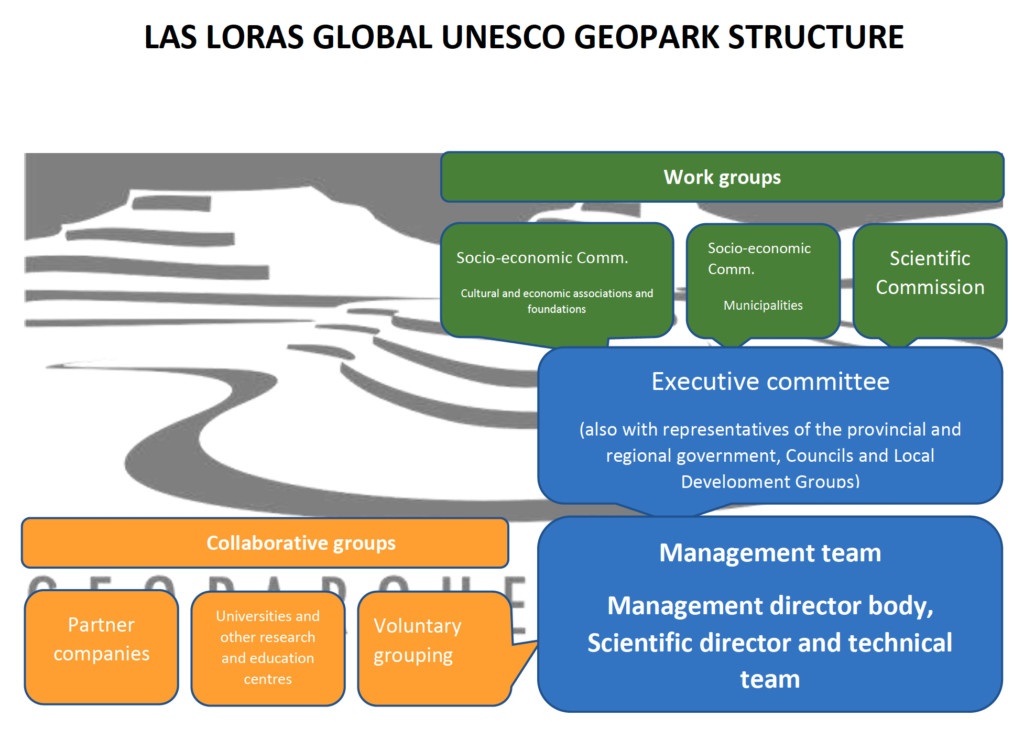
2. Scientific Committee
Formed by a team of researchers linked to the territory of the Geopark, mostly geologists. A large part of this team was formed in 2004 in the expert consultation session held in Revilla de Pomar. Later, new researchers have been incorporated. It is directed by the Scientific Coordinator, who will be the representative of this Committee in the Executive Commission.
Functions:
- Promote scientific studies in the area.
- Scientific advice to the Executive Commission
- To arbitrate and advise on decisions that affect the scientific content of the Geopark.
3. Socioeconomic Committee
Municipalities Working group
16 municipalities: represented by their mayors
Associations and foundations working group
33 Associations and foundations represented by their presidents
Functions:
- Compile all the improvement actions and concerns of the local population, regarding the Geopark, so that they can be transferred to the Executive Commission and can thus appear in the Geopark Action Plan
- Represent local businesses.
- Provide guidance on the distribution and priority of actions.
- Collaborate in the promotion of geotourism and the actions carried out in the Geopark
- Promote business training related to geotourism and geoconservation.
Educational and Scientific Project
The Geopark educational and scientific Project is made up of four different programmes directed to four target groups:
- Secondary school students in the region or from other regions. Work has also been done with primary school students by means of collaboration and support in other entities programmes, such as Caja de Burgos-Obra Social la Caixa Foundation “Do you know your town” and “Your town is full of life” programmes.
- Local population.
- Students and researchers at universities from inside the region or beyond.
- Visitors.
PROGRAMME 1. SCHOOL GROUPS
Several educational programmes have been developed by the Geopark over the years. The programmes are intended to support secondary and primary school teachers on site. One of the main aims is to give real examples, at natural sites, of many of the contents studied in the classroom.
Landscape, fossils, geological processes, knowledge about ecosystems, the link between the natural and physical environment and human beings and attitudes which favour environmental sustainability are some of the topics within our activities. The aim is to bring the learning and development of the natural heritage within Castile and León, and especially within the Geopark, closer to learners.
Due to the Covid-19 crisis the best solution for this year is that we go to the classroom, and f it is possible later on, you just have to worry about the travel and we will organise all the rest for a guided field trip.
Activities:
– Activity 1: A one to two hours educational activity at school, according to availability. The number of students shall be determined by the Covid-19 protocol at each school. Each student will be given a field notebook to be worked at school with the help of a Geopark technician.
– Activity 2: Before the guided field trip teachers should revise the contents of the field notebook with their students. Support material may be provided. The teachers can opt to use the notebook throughout the school year as a working tool.
– Activity 3: Half-day guided tour within the Geopark (approximately from 10 am to 2 pm). Maximum number of 20 students divided in two groups of ten with one teacher for each group, according to Castile and Leon Regional Government recommendations for this type of activities.
PROGRAMME 2. LOCAL POPULATION
Activities: Information talks, tours, exhibitions, and participation in the Geoloday, Geological Week and Volunteer Programme.
PROGRAMME 3. GROUPS OF UNIVERSITY STUDENTS AND RESEARCHERS
Activities: immersion programmes in order to understand the territory, grants for research projects, conferences, guided tours and documentation centre.
PROGRAMME 4. Tourist
Activities: Visits to Information centres, Information talks, tours, exhibitions, and participation in the Geoloday, Geological Week and Volunteer Programme.
OTHER EDUCATIVE EXPERIENCES: ERASMUS, INTERCHANGES, STUDENTS IN PRACTICE, MASTERS, FINAL DEGREES…
These years we have been involved in several Erasmus plus and interchange projects at the local level, one with the Campos de Amaya Secondary Institute in Villadiego, with a student exchange program with three other European Geoparks. For more information at:
http://iescamposdeamaya.centros.educa.jcyl.es/sitio/index.cgi?wid_seccion=41
http://lyk-peir-mytil.les.sch.gr/fourgeoparks/index.php/news
Another three host and tutored project for a master’s degree student of the Master of Geological Heritage at the University of Minho in Portugal and a student of Geology at the University of Aveiro. Also a student at the University of Mexico!
At the local level in 2019 there has been an exchange of students and experiences between the Villadiego Institute and the Aguilar de Campoo Institute and they have had the opportunity to present it at the 15th European Conference on Geoparks
We also have national internship students in the Geopark, students of pedagogy, geology, geography, etc …
This 2019-2020 academic year we have started a project with the students of Professional-Administrative Training in Aguilar de Campoo. They are creating business projects linked to the Geopark! Quite a challenge!
GEOFOOD
The GEOfood initiative, lead by Magma UNESCO Global Geopark since 2013 , has its route within the values of UNESCO Global Geoparks.
Global Geoparks mission is based on local communities engagement and sustainable development actions in education, businnes and research, GEOfood mission is also focused on supporting local enterprises, educate Geopark´s visitors and inhabitants and to run researches for developing innovative tools for sustainable development
GEOfood has been thought as one of the possible Geopark´s answers for comply with the worldwide agricultural challenges detected by United Nation within the Sustainable Development Goals (UNSDG) and specifically from FAO (Food Agricultural Organization Agency of the United Nations).
The adoption of the GEOfood brand within the UNESCO Geoparks could in fact support the achievement of several UNSDG’S targets detected within the Sustainable Development AGENDA, specially the targets related with “Climate change” adaptation, “Education” and “Hunger”.
he GEOfood certified “quality “derives not from any chemical composition but it is build up thought the stories, traditions, heritage of the local communities crossed with the geological peculiarity of each Geopark areas, it aims at empowering local communities in increasing the awarness of the importance of local resources both biotic and abiotic, strongly emphasizing the strong connection and intercorrelation between biodiversity and geodiversity.
The GEOfood is an innovative way to connect all targets of the population with the geological history and research running in the territory, in fact food is an international language that anyone can understand: through the food we like to connect people with soil, nature and strengthen the food education towards km zero food and responsible use of the resources.
More information here: https://geofood.no/

RELATED POSTS

April 15, 2025 8:21 am
Children’s Culture Week (Lastenkulttuurin juhlaviikko) is an annual, nationwide festival...

October 29, 2021 4:25 pm
Local Dissemination Activity: 11th November, 16.30 in Ravenna and on...
August 3, 2022 5:20 pm
The “Take Home Exam” is the most commonly used approach...
November 14, 2022 4:08 pm
This project aimed to reflect on the updating of tradition...
December 6, 2021 10:01 pm
Try playing a memory game. It will be fun. How...
February 3, 2022 5:17 pm
“EU-backed researchers studied different ecological management practices on Scottish livestock...